DarkSky Oregon
Welcome to our Blog. Do you want to learn more about how you can help protect the night?
To learn more :
Oregon's Night Skies
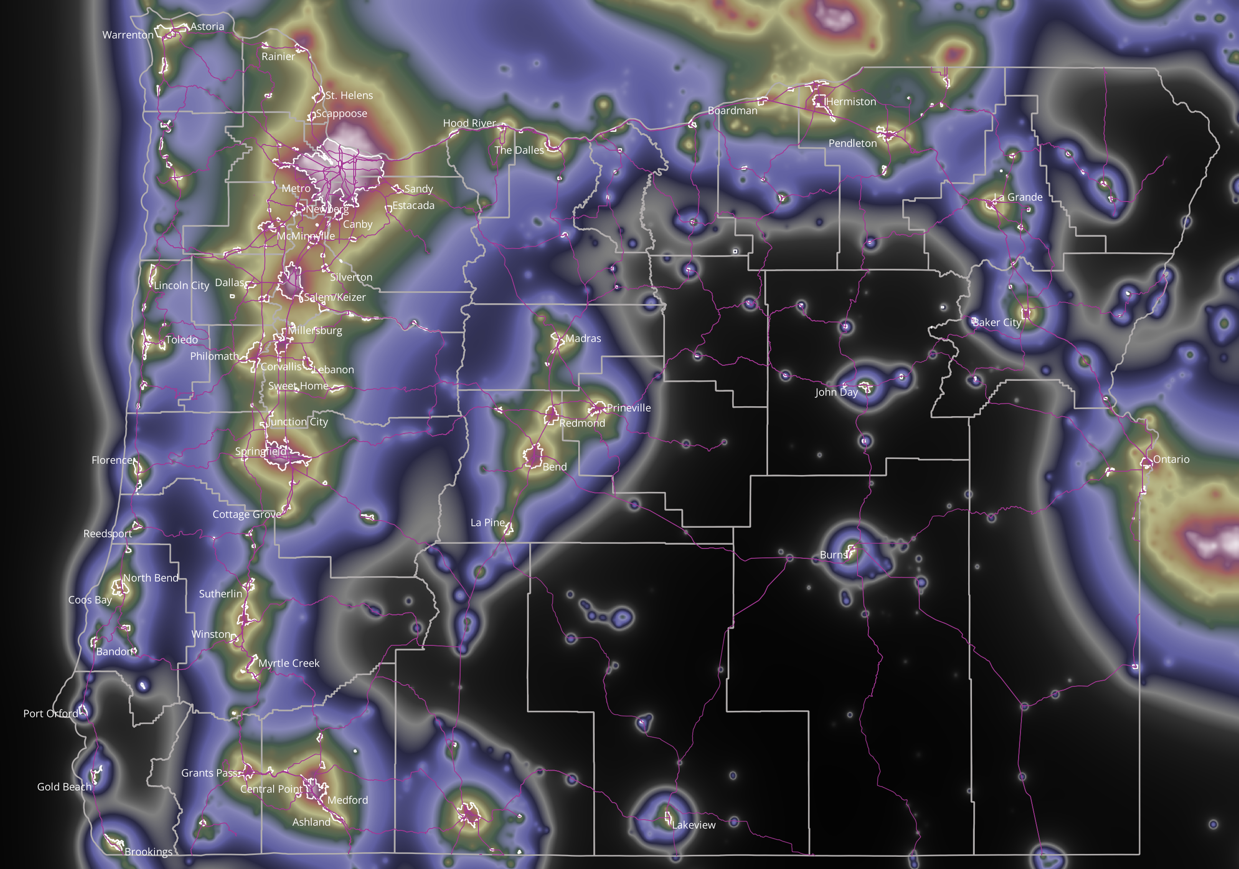
Sky Brightness Map - Oregon
Large areas of Oregon still have dark skies at night -- the green, purple, and especially the black areas in the map have dark, Milky Way skies. The white, red and yellow areas have light-polluted skies in which few stars are visible.
The map shows the amount of skyglow directly overhead at each spot. The amount of skyglow is derived from night time satellite images, which were taken at about 2AM during the year 2022. The map shows county boundaries, main roads and the urban growth boundaries of Oregon cities. Each city lies under a dome of skyglow that extends far outward, caused by wasted light, escaping upward and scattered by the atmosphere.
Here are two links for finding dark-sky locations:
www.lightpollutionmap.info
www.darkskyfinder.com
Port Orford Night Sky
Port Orford is home to some of the most beautiful scenery, and that includes its incredible expanse of night sky.
Northern Lights from Central Oregon, April 2023
Northern Lights over Bend, Oregon - April 2023
Light pollution - Dark Skies are not just for the Birds! April 25 Presentation
April is Earth Month, peak bird migration, and International Dark Sky Week (April 22-30). It's a perfect time to talk about light pollution.
Oregon Parks and Recreation Camping & Dark Skies Report
Summary:
This analysis concludes that OPRD is better endowed with potential dark sky park locations than previously believed.
This is an update of a GIS project by IDA Oregon to identify those Oregon Parks and Recreation Department properties that could qualify as International Dark Sky Parks. Qualification as a Dark Sky Park is based in part on meeting a required level of night sky darkness. That darkness is achieved in areas that are relatively unaffected by light pollution. Another requirement is that people are allowed to be present at night, so we limit the analysis to properties that allow camping. This analysis uses skyglow models derived from night time images acquired by a NASA satellite sensor (VIIRS) to estimate how dark the night sky is at each location.
Northern Lights from Central Oregon, March 2023
Northern Lights video from Bend, Oregon - March 2023
Yachats needs to discuss “night sky” initiative and intrusive lighting
Yachats is magical place blessed with an abundance of natural beauty to enjoy. While everyone appreciates the magnificent Pacific Ocean to the west and Cape Perpetua to the south, one of the things that many people fail to realize is our magnificent nighttime sky.


